


Kythnos is a mountainous, rocky and barren island, its peak, Kakovolos, at 356 metres, situated at the northern section. Kythnos’ coastline, measuring a total of 110 kilometres, features many bays, small and large, dozens of sandy beaches and abundant natural beauty, such as a narrow sandy strip of land connecting the islet Agios Loukas with Kythnos, at Kolona bay in the northwest.
Impressive large stone steps along a trail headed towards Agios Ioannis bay/Photo: Stefanos Psimenos
The island features two thermal spas, at Loutra bay, in northeastern Kythnos, at a hydrotherapy centre to soon be developed into a five-star spa hotel. Kythnos’ vegetation mainly consists of shrubs, primarily thyme and mastic shrubs, caper bushes, as well as numerous tamarisks offering shade at many of the island’s beaches.
Kythnos’ northwestern shores have cliffs, their rocks forming sea caves, where Monachus monachus seals maintain nests. Springs and streams feature at many points on the island, while small waterfalls form at some cliffs. Shrubs and rocky terrain are habitat for many bird species, as well as hares, hedgehogs, snakes, lizards and other species.

The island’s mineral wealth prompted mining activity, from antiquity to the interwar period, at Dryopida, Skouries, Kolona bay and other locations. Until not too long ago, silkworms were bred on Kythnos for silk production used to make clothing and household items. Unfortunately, local silkworms are a thing of the past, along with mulberry trees that once adorned the island. These trees were cut down for local lumber needs. Farming and livestock farming have remained, but not as a main occupation, as most locals have turned to tourism.

Attractions
Hora, Kythnos’ main town, has been inhabited without interruption since the 17th century. Typical Cycladic architecture has been maintained at the town, featuring churches, whitewashed houses, small squares, cobbled paths, steps, ornate roofs and wind mills. Some of the island’s most interesting churches are situated in the main town. They include Agia Triada, Agios Savvas (17th century), Metamorfosi Tou Sotiros, and, on the outskirts, renowned Panagia Tou Nikous, which served as a spiritual centre during the period of Ottoman rule. Many terrific cafes, bars, tavernas, food shops, as well as gift shops also selling local products, line the cobbled path running through Hora. Vehicles are not permitted inside the town.

The settlement Dryopida also features distinctive architecture. The ceramic tile roofs and neoclassical-style houses are impressive. Winding alleys with arches and steps are even more picturesque than those of the main town. This village hosts the Folk and Byzantine Ecclesiastical Museum, as well as three interesting churches, Agia Triada, Agios Panteleimonas and Agios Minas. The Katafyki cave, beautifully decorated and one of Greece’s biggest, is the main attraction at Dryopida. In the past, it had been used as a refuge, hence its name, during difficult times. Mining activities have caused damage to the cave.

Vryokastro, Kythnos’ ancient capital, inhabited from the 10th to 7th centuries BC, is situated at an elevated point between two bays, Episkopi and Apokrousi, in the island’s northwest. Sections of walls that surrounded the ancient town may be seen, along with the remains of a sanctuary that was dedicated to a female deity. Kythnos’ ancient capital, Vryokastro, has remains of old walls and buildings.
Oria Castle was first inhabited when the ancient acropolis at Vryokastro was abandoned. The location was eventually also abandoned following a bloody raid by the Ottomans, according to tradition. Lots of ruins and two churches, Panagia Eleousa (1738) and Agia Triada, may be seen in the area. Two small and lovely beaches, Sklavou and Gialoudi, accessed only by boat, are situated below Oria Castle.

The village Loutra, named after local thermal springs that have been used from at least the 11th century, is situated approximately 4 km northeast of Hora. This once-traditional settlement has become Kythnos’ biggest and most developed tourism resort with lots of hotels, restaurants, bars, a marina, as well as a scuba diving centre. The village’s Agioi Anargyroi spring is located at the hydrotherapy centre. A first domed water tank was built in 1782 at this spring, while construction of the current-day facility began in 1836. It was expanded over a number of stages, esteemed architect Ernst Ziller making the most significant contribution. The spa acquired its current shape in the 1960s, when its management was taken over by EOT, Greece’s National Tourism Organisation, and the facility was named Xenia.

Kythnos has many beaches, most of which are located at small, protected bays. Kolona beach, a narrow sandy strip connecting the islet Agios Loukas with the island and separating Kolona and Apokrousi beaches, is the island’s most famed beach, at the northwestern edge. Kolona and Apokrousi beaches are both protected from northern winds by Mount Kakovolos, directly behind. It is a favourite spot for yachts. The entire western side of Kythnos features a succession of bays, offering multiple swimming choices. All the west coast’s main villages have sandy beaches with tamarisks for shade. In between, many smaller sandy beaches may be reached via land or sea. These include Mavrianos and Styfo beach. Even quieter beaches exist, if preferred.

Gaidouromantra, Simousi, Skylos and Ai Nikolas are all delightful beaches in the island’s south, between Agios Dimitrios and Kanala. Moreover, Zogaki, Lefkes, Agoritsa and Agios Stefanos are also lovely beaches. Kythnos’ northwest also features a number of beautiful beaches. Protected from winds and covered with sand or fine pebble, they include Livadaki, Arkoudi, Kavouroheri, Agia Irini and Agios Sostis.
Trails
Route 1- Dryopida – Lefkes, 2.8 km, 50 min
Begin from Dryopida’s main square headed in a southwesterly direction, along a cobbled path leading to Agios Vlasios, at the settlement’s southern outskirts. From there, take the dirt road that soon leads to the main paved road. Follow this main road, headed north, for just 60 metres until you reach an intersection with an accessible dirt track to your right. Take a right turn here and, 50 metres ahead, you will reach the continuation of a trail running between drystone walls. It leads to a first intersection which, to the right, connects with a trail for Kanala, described in Route 2.

Turn left and the trail soon splits into two. The route to the left leads to the main road. Take the route to the right, a clear trail with a lovely view of Serifos and the sea. It runs downhill to a ravine, passes by the Ai Giannis chapel, and enters a lush setting with a spring and traditional laundries once used by households. Opposite the creek, a number of big dilapidated buildings, locally known as Spitares, were once used as offices by the local mining company. Carrying on from here, along an easy, gentle passage alongside the creek, leads to Lefkes beach.

Route 2– Dryopida – Kalo Livadi – Panagia Kanala, 10 km, 3 hr
Begin your trek from Route 1’s starting point and, at the trail’s first intersection, turn right and continue in a direction towards Mathias. Once slightly past a house to be encountered, the road diverges. The left turn-off reaches above the aforementioned dilapidated buildings (Spitares) and ends up a little further down at a point with a lovely view. Take the right turn-off, instead. A spring on the left side of the trail, at Panagia church, is ideal for a refreshing break. The trail continues smoothly towards a dirt road that leads to Liotrivi. Turn right at this dirt road, cross the paved road to be encountered a little further ahead, and carry on along the dirt road in a southerly direction.

Roughly 400 metres further on, reenter the trail, which runs between drystone walls and heads downhill towards Kalo Livadi. Follow the trail for approximately 1 km to end up at the paved road connecting Liotrivi with Kalo Livadi, at a bend in the road where the Panagia Kalolivadiani church is located. Head down the steps running alongside the church to reach Kalo Livadi beach. Cross the beach all the way to its end and take an uphill trail leading to the dirt road. Turn right at the dirt road and carry on for 500 metres, in a northerly direction. You will once again encounter the trail to your left. It runs parallel to the main paved road leading to Kanala and heading downhill towards the creek, before ending at a small beach, Antonides. From there, head up to the settlement and its beaches.
Route 3 ) Agios Mamas – Agios Dimitrios, 1.8 km, 40 min
A very lovely and easy-to-cover trekking trail, this route is situated in Kythnos’ south. A wide corridor between drystone walls runs downhill, smoothly, towards a collapsed lime kiln. The route diverges here. Taking the left turn-off leads to Agia Irini church. If you take the right turn-off, follow the lush ravine, filled with oleanders, until you reach the settlement Agios Dimitrios.
Route 4 ) Agios Konstantinos – Flabouria, 2.1 km, 35 min
This trail begins at Agios Konstantinos and heads down the slope in a westerly direction, towards Flabouria. A clear path that is defined by drystone walls, this trail offers a delightful descent over wide ancient steps leading to the ravine. Carrying on, parallel to the ravine, leads to the settlement’s houses and beach.
Route 5) Towards Panagia Papatzoanou (Flabouria), 0.4 km, 10 min
A short yet pleasant route begins from the main road, 200 metres south of the Agios Konstantinos chapel, runs downhill in steps and along a winding direction, over slate stones, before reaching a gorgeous chapel, Panagia Papatzoanou, at the entrance of a lush ravine.

Route 6) Agios Konstantinos – Merihas, 4.2 km, 1 hr
The starting point of this route is 100 metres north of the Agios Konstantinos chapel and an intersection of the main road and a paved road leading to Flabouria. A pleasant dirt road, it mildly descends the slope of a hill. Merihas and the harbour are visible in the distance.
Route 7) Hora – Vryokastro. 2.7 km, 45 min
Head away from Hora, along the main paved road towards Merihas, then, 1 km down the road, turn right onto the road headed for Apokrousi. Pass the point where the road meets (to the left) a dirt road running to a wind turbine. The trail begins 300 metres away, to the left. It is not signposted. Some sections of this trail, which runs south, pass through areas with dense shrubs. Having covered approximately 600 metres from the start of the trail, you will encounter the Agios Nikolaos chapel, and, a further 600 metres on, another chapel, Hristos. The trail, used mostly by local shepherds to cut corners, ends up at a paved road in the Diasela area, at the bottom of Vryokastro hill.

Route 8) Vryokastro – Apokrousi beach – Vryokastri islet, 2.3 km, 50 min
This route begins from the Diasela area, at the paved road linking Meriha and Hora. The trail is easy to cross and clearly defined by drystone walls. It is not signposted. After covering the northeastern side of the Vryokastro hill, you will end up at Apokrousi beach.

Cross the beach to reach its southern edge, from where another trail begins, running by the northern and western sections of Vryokastro hill. This section offers a lovely view of Kolona beach. The trail concludes at a remote beach, opposite the islet Vryokastri, at a point where the ancient city’s harbour was located.

Route 9) Dryopida – Episkopi, 3.9 km, 1 hr 10 min
This route starts at the centre of Dryopida, headed for the village exit, towards Meriha. A little before the local community office, head downhill along a cobbled path running to Katovrysi. Continuing downhill once past Katovrysi, you will reach a stream whose riverbed has been developed into a road. Follow it towards the west and, 500 metres down the road, directly before encountering a cement water tank, take the uphill trail to the right. This point is not signposted but clearly defined as it runs between drystone walls. The trail initially heads uphill for approximately 1 km and then runs downhill, mildly, to end up, 800 metres further on, at an easy-to-cross dirt road that intersects with the main paved road a little before reaching Episkopi.
Route 10) Loutra – Oria Castle, 3.6 km, 1 hr 45 min
Follow the paved road running north from Loutra and, 1.3 km ahead, at the intersection with the main road, you will see a trail to your left. It is not signposted, but the route is clearly defined as it runs between drystone walls. It is rocky and with low vegetation. Continue for approximately 1.5 km, where the route intersects with a dirt road. Turn left here and, 400 metres ahead, you will reach a chapel, Agios Filippos. A trail leading to Oria Castle begins immediately after the chapel, to the left of an accessible dirt road that continues running away from the chapel in a northerly direction. The trail to the castle is clearly visible, runs smoothly, and marked with faint white markings on rocks. You may see other trekkers here, even though the castle and churches are dilapidated. The route covers rocky ground and offers a lovely view of the castle and sea.
Route 11) Loutra – Hora, 3.3 km, 1 hr
Follow the main paved road running from Loutra to Hora. At the intersection with the paved road headed for Oria Castle, take a paved trail running south. It is smooth and cleared of overgrown greenery. The trail mostly runs almost parallel to the main paved road, which it actually crosses a number of times before reaching Hora. A little prior to the PPC power utility facility, you will encounter another crossing over the main road. The trail then continues a little further before ending slightly before a petrol station on the main road, at the outskirts of Hora.

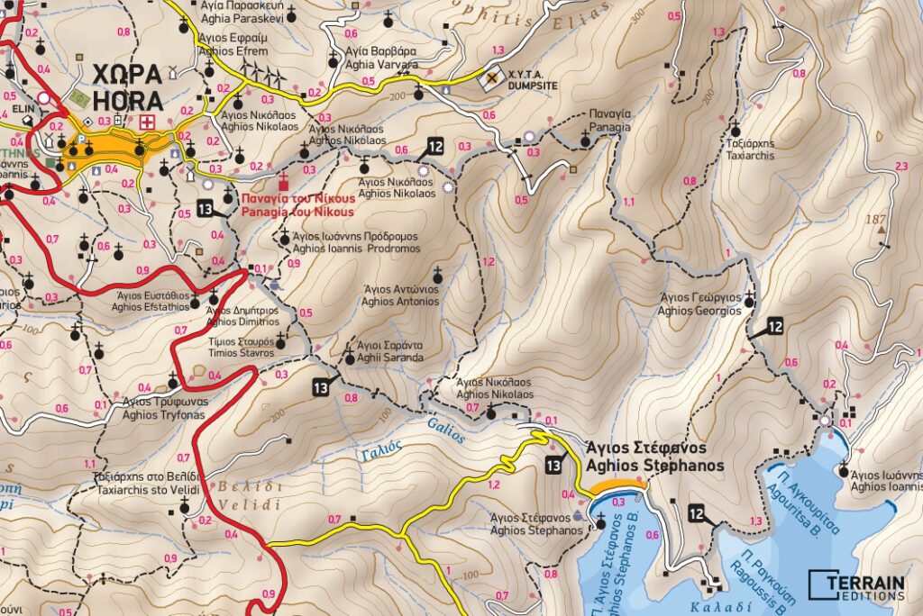
Route 12) Hora – Panagia Tou Nikous – Agios Ioannis – Agios Stefanos, 7.7 km, 3 h
Take the cement road running east from Hora towards the Panagia Tou Nikous monastery. A little before reaching this historic monastery, the cement road becomes a dirt road, running all the way to the monastery, where our trail begins. The next attraction, Agios Nikolaos, a chapel, is also a great location to stop at for a rest and the view. The trail runs uphill for 500 metres and diverges. At this point, you will see a small threshing floor. Follow the signs towards the left. Heading to the right leads into fields.

Carrying on, the trail crosses a dirt road. Continue for a further 250 metres beyond this crossing to reach a turn-off. Turn right, onto the downhill section. The trail runs by the Panagia Tou Nikous monastery, seen to the left, then a chapel to the right, before reaching an intersection without signposts. Taking a left here leads to Agios Ioannis beach. The initial section of the route to the right is clearly defined as it runs between drystone walls, but then becomes a little vague as it runs through fields, before heading downhill, between the drystone walls, to reach the beach and a settlement, Agios Stefanos.

Route 13) Agios Stefanos – Hora, 3.9 km, 1 hr 30 min
Take the paved road beginning from the western edge of Agios Stefanos beach and headed towards Hora. You will soon reach an intersection with a dirt road to your right. Take this road all the way to its end. From there, an easy-to-cover trail runs all the way to Hora, running uphill amid a ravine setting of exceptional, dense greenery. You will encounter stone steps that rise out of the ravine, towards the left, followed by a small fence, which needs to be crossed over. Then, continuing along the trail, you will reach, without any other obstacles, an intersection with a main road that links Hora with Dryopida, below Ai Giannis O Prodromos church.
TERRAIN has just published an extremely detailed trekking map (1:25,000) covering Kythnos, with latest updates all the way to 2022. It presents all the island’s trails, beaches, churches, chapels, monasteries, and other attractions with precision. The trekking map may be found at selected shops on Kythnos and in Athens, as well as at http://www.terrainmaps.gr/#products
This map may also be downloaded at Avenza Maps (www.avenzamaps.com).


