


The island got its name from the nymph Astypalaea who was Europa’s sister and Poseidon’s wife. During antiquity it was also known as “Ichthyoessa”, due to the abundance of fish that swam in its waters, as well as “Theon Trapeza” (Gods’ Table) due to the abundance of produce and game on the island.
In fact, the hares on the island were so many that the islanders resorted to the oracle of Delphi to seek advice on how to rid the island of this small animal that caused such damage to their crops. Pythia told them the obvious: “get hounds and hunt them”. The people of Astypalaia seem to have religiously followed the advice and so, today, you won’t find many hares on the island, but you can enjoy amazing hiking routes that end on some of the most amazing beaches of the Aegean.


Hiking
The trails all over Astypalaia, that have been created by the residents centuries ago, so that they can go from one village to the next, reach their farms and the grazing lands for their herds, stretch dozens of kilometres. Next to these trails there are dozens post-Byzantine and more recent chapels that add a special touch to the already amazing experience of the trails. However, the trails are not fully marked, so you need to have a good, updated hiking map with you at all times. You should also bear in mind that there are no drinking water springs on the island, nor are there many trees to provide shade, so you need to have water with you, a hat, sunglasses, light clothes and sun-cream. During the summer, we recommend starting your hike very early in the morning, and definitely stopping during the hot midday hours, and resuming your hike later in the afternoon.
Around the artificial lake, towards the chapel of Stavros, 5.8km – 2h
Yes, this bare and dry island has a lake. It’s artificial, of course, but it’s large and beautiful. It’s located on the western edge of the valley that spreads behind the village Livadi, just 3km west of Hora. This hiking trail starts at the north-eastern edge of the dam and goes along the north bank of the lake. After 1km, the trail goes up the mountain slope, by the north edge of a creek. After another 1,300m, it comes out on a dirt road you should follow for about 600m to reach the chapel of Stavros. Return to the lake following the same trail on the opposite direction and then take the difficult and not very clear path along the south bank of the lake. After 1km, you’ll reach the dam be back at the trail’s starting point again.

Agios Ioannis tou Makri church – beach of Agios Ioannis, 1.6km – 30min
This wonderful path starts at the Byzantine church of Agios Ioannis tou Makri and ends at the beach of the same name. Park your vehicle at the clearing by the road, next to the church, and climb down the steps that end at a spot between the church and a neighbouring farmhouse. A sign there informs you that you need to go left to get to the beach. The trail is clear and marked with red paint. You’ll come across two small doors – you need to open them to get through and close them behind you – and then you’ll go downhill towards the creek, coming across small waterfalls, and bodies of water, as well as 10m tall waterfall surrounded by green, to end up a bit later on an idyllic beach.
Agios Panteleimonas– Panormos bay, 2.1km – 40min
This hike starts about 120m south of the chapel of Agios Panteleimonas, at the location of a fold. You have to cross the field right next to fold and follow the dirt road that goes down to the creek. After about 180m, right at the creek, the dirt road goes uphill on the opposite slope, but you’ll have to get off the dirt road, into the creek and head north. From here, you can choose the easiest path, either on the creek’s bed or on one of the animal paths on both sides of the creek, until you reach the sea. The first beach you’ll come across is Lantes, and right next to it, on the west, is the beach Panormos where you’ll also find the gorgeous Byzantine chapel of Agios Nikolaos.


Panagia Vryson – Pahia Amos beach – Italian Observatory, 8.2km – 3h
You start behind the church of Panagia Vryson, heading northwest, on the path with the signs on the iron poles. In essence, it’s an animal path, with the occasional white-and-yellow marking or just poles guiding you downhill towards the creek of Kakos Potamos river. However, even if you miss the poles, if you follow the course of the creek, you will end up on the beach anyway. On the right (east) edge of the beach, the stone steps built by the Italians during the Italian rule of the Dodecanese (1912-1943) to link the coast with the military observatory are clearly visible. The steps go up a bit, and then end on a path that slowly fades. As you get further away from the coast, the path goes up the Pervoles hill and reaches an abandoned Byzantine chapel. Look for the signs to make sure you’re heading the right way, until you see, up on the mountain, the Italian World War II military observatory. To get there, you will walk on the easy animal path until you reach the old structure that today is only inhabited by goats. The view from there is really beautiful. The return path (with very few markings) becomes a bit unclear, but the route is relatively intuitive since the Panagia ton Vryson church is always within sight. You can choose any animal path you like, and then, you’ll pass by a fold, and on the dirt road, you’ll reach the starting point again.

Agios Konstantinos – Agios Savas – Panagia Amorgiani – Agios Konstantinos, 5.6km – 2h
Take your vehicle to the beach of Agios Konstantinos and start your hike on the path that starts right next to the last house, about 100m from the beach. The path goes south, along the coast, and there are some small pebbled beaches called Lantes. The largest and most beautiful among them is the southernmost one, the 3rd Lanta, about 900m from the hike’s starting point. Continuing southbound, you’ll go up the slope, and, after 1.5km (from the starting point) you’ll reach the post-Byzantine chapel of Agios Savas. At this corner of the island, there used to be large older buildings, of which only the stone enclosures remain, as well as the ruins of many farmhouses. There is no clear path from Agios Savas, but there are many animal paths that go up towards the top of Ehili, that can be seen in the southwest. Go up the norther slope of Ehili, until you reach the old farms with the stone enclosures, and from there head west on the destroyed farm road (basically wheel tracks on the weeds) that crosses those farms. A bit further down the road, you’ll walk between the ruins of an abandoned farm village and, on your left, you’ll see a large field and the post-Byzantine chapel of Panagia Amorgiani with the large pine next to it, the only tree on this rocky corner of the island. From there, go down the bumpy farm road northbound, and about 600m after Panagia Amorgiani, you’ll have reached the main road of Agios Konstantinos, where you turn right (east) to return to the starting point and complete this route.

Vatses – Cave of Negros, 300m – 20min
There’s no marking, nor is there a proper trail. From the northwest edge of the beach Vatses, behind the beach bar, you climb the slope walking on the grey limestone northbound. After 300m, at 160m altitude, you’ll see the cave of Negros, which actually is two caves, with the impressive stalactites and the amazing view towards the sea and the coast.

Kaminakia beach – Hellenistic tower, 500m – 30 min
Two creeks end up at Kaminakia beach, at the bay of the same name. If you go on one animal path on the west bank of the west creek, after about 500m you’ll come across the impressive ruins of a tower of the Hellenistic period (330-30 BC), and the view from there is stunning.
Vai beach – Hrisi Amos beach, 2.3km – 40min
This is one very beautiful hiking trail along the coast on the west side of Vai bay. Vai beach and Hrisi Amos beach are accessible by a dirt road, so there will be people there, but if you go on the coastal trail that links the two beaches, you’ll cross beautiful secluded landscapes, and pass by some very pretty small pebbled beaches you can have all to yourself.

Agrilidi – Panagia Poulariani – Agios Fokas, 5.2km – 3h
In the past, there was a main path here, that linked the farm village Agrilidi to the chapel of Panagia Poulariani and the chapel of Agios Fokas. However, for many decades now the village has been abandoned and the houses have fallen apart, while the path has disappeared under the vegetation. Some small goat herds remain in the area, and so some animal paths are still open. After the last house on the eastern edge of Agrilidi, go up the slope on one of the animal paths, with a course of about 70 degrees, around 200-250m distance from the coastline. After about 1,200m you’ll reach the impressive red rocks that stand tall in the waters of the Kokkinogremos area. It’s worth heading to the beach for a swim in the crystal-clear waters. From Kokkinogremos on, the trails becomes challenging. For the next 1.6km, until you reach the dirt road north of Panagia Poulariani, you’ll be on a clear landscape with only faded animal paths and many thorny bushes. Head north-east and cross two creeks at the Kakia Skala area, choosing the spots that seem more accessible. The last part of this trail, 1.8km long, from Panagia Poulariani south, until the coast and the beautiful beach Panagia Amoudi, is easy and with a clear path.
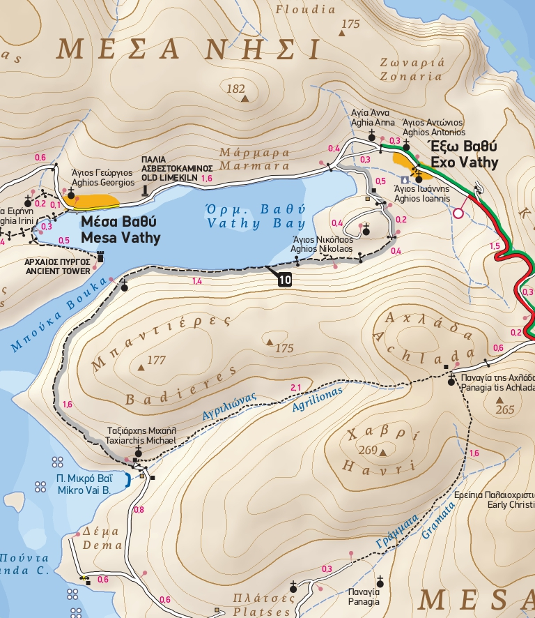
Route 10 (extract from TERRAIN’s hiking map of Astypalaia, 2022)

Mikro Vai beach – Exo Vathi , 4km – 1h 15min
A gorgeous route on an easy trail among Phoenicean Junipers with an amazing sea view. From the Mikro Vai beach, follow the road that goes uphill towards the chapel of Taxiarhis Mihail, and at the top of the turn (30m before you reach the chapel) you’ll see red markings marking the trail’s start. Once you find its start you won’t lose it. About 1.6km from the starting point, at the narrowest point of Bouka (Vathi bay’s mouth), you’ll pass by the ruins of a Byzantine church of the 10th century. Right opposite, at the other side of the bay’s mouth, you’ll see the ruins of a Hellenistic tower (330-30 BC). From here, follow the trail right next to the sea, until you reach a field south of the Agios Nikolaos hill. Go up the hill and you’ll reach the dirt road that will lead you to the village Exo Vathi.
TERRAIN maps have published a detailed hiking map of Astypalaia at a 1:25.000 scale, that was updated in 2022 and you can get here: http://www.terrainmaps.gr
Read also:
Five reasons to visit Astypalaia
Schinoussa: A lilliputian island full of gorgeous, isolated beaches